


Introducing FBI-Sourced County-Level Crime Data in L2’s National Voter & Consumer Databases
Understanding where people live has always been just as important as understanding who they are. Today, L2 is expanding that lens with the addition of county-level crime data sourced from the Federal Bureau of Investigation, now fully integrated into L2’s national voter and consumer databases.
This new dataset adds a powerful contextual layer to L2’s already robust universe—helping clients better understand the environments that shape voter attitudes, consumer behavior, and community priorities.
A Smarter Way to Analyze Crime Data
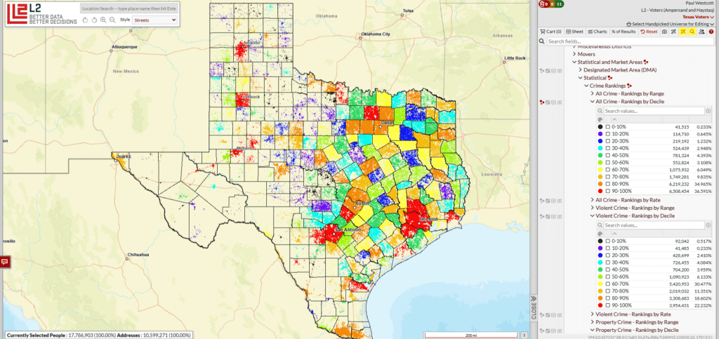
Rather than presenting raw counts or hard-to-interpret rates, L2 organizes crime data into deciles, ranking every county from lowest to highest across three key categories:
- All Crime
- Violent Crime
- Property Crime
Each county falls into a percentile band (0–10%, 10–20%, … up to 90–100%), making it easy to compare regions relative to one another. This approach simplifies analysis and allows users to quickly identify patterns and outliers without needing to normalize data themselves.
For example:
- Counties in the 90–100% range represent the highest relative crime concentrations nationwide
- Counties in the 0–10% range represent the lowest
This standardized structure ensures consistency across geographies and allows for seamless integration into modeling and targeting workflows.
Why This Matters
Crime—and perceptions of safety—plays a meaningful role in how people think, vote, and engage with their communities. By incorporating this data directly into L2’s ecosystem, users can now:
- Add geographic context to targeting strategies
- Better understand voter and consumer sentiment drivers
- Identify regional trends that may influence behavior
Whether you’re analyzing suburban shifts, urban engagement, or rural outreach, crime data provides an additional signal that can sharpen your understanding of key audiences.
Practical Use Cases
This new data layer unlocks a wide range of applications across political, advocacy, and commercial use cases:
Political & Public Affairs
- Target messaging around public safety in high-crime counties
- Identify areas where crime is less salient and shift messaging accordingly
- Analyze how crime exposure correlates with modeled party ID or issue preferences
Advocacy & Nonprofits
- Focus outreach efforts in communities most impacted by violent or property crime
- Support grantmaking, resource allocation, and program design
Commercial & Consumer Targeting
- Align marketing strategies with community characteristics
- Incorporate safety and location-based insights into segmentation models
Because this data is structured at the county level and integrated into L2’s broader dataset, it can be layered with:
- Demographics
- Consumer attributes
- Modeled scores (including HaystaqDNA)
- Geographic and political boundaries
Fully Integrated into L2 DataMapping
As with all L2 data assets, this crime dataset is immediately actionable. Users can:
- Build audiences directly within L2 DataMapping
- Run “what-if” scenarios across different geographies
- Export selections via SFTP, S3, or Snowflake
- Combine crime data with custom models and external inputs
This means no additional processing, no manual joins, and no delays—just instant access to a richer dataset.
Bringing More Context to Every Record
L2 has always focused on delivering the most comprehensive and actionable data available. With the addition of FBI-sourced crime data, clients gain a deeper understanding of not just individuals—but the communities they live in.
In a world where context drives strategy, this is another step toward helping organizations make smarter, faster, and more informed decisions at scale.
